<map>
- 渲染地图
- 以属性的形式设置各种地图插件
- 默认大小 300*150
<map id="myMap" show-location />
| 属性 | 说明 |
|---|---|
| longitude | 经度;必填 |
| latitude | 纬度;必填 |
| show-location | 显示带有方向的当前定位点 |
| show-scale | 显示缩放标尺 |
| show-compass | 显示罗盘 |
| markers |
在地图上显示标记的位置;结合地图服务API - 地点搜索实现
latitude:标记经度; 必填
longitude:标记维度; 必填
iconPath:标记图片路径; 必填
id:标记id;number;注意是数字类型;每个标记的id应该不同; 必填
width:标记宽度;实际开发 必填
height:标记高度;实际开发 必填
label:标签;在标记下方显示信息;对象类型
callout:单击标记,在上方显示content信息,单击地图其它地方,信息消失;对象类型
|
| bindtap | 单击地图,获取单击点经纬度信息 |
| bindmarkertap | 单击地图标记,获取标记点id |
| bindcallouttap | 单击标记的气泡触发 |
| bindlabeltap | 单击标记的标签触发 |
调试的时候,应结合预览和真机调试共同使用
[渲染层错误] [Component] <map>:width and heigth of marker id 1 are required
| 属性 | callout | label |
|---|---|---|
| display | √:BYCLICK、ALWAYS、NEVER | × |
| content | √ | √ |
| color | √ | √ |
| fontSize | √ | √ |
| anchorX | √:marker 对应的经纬度 | √ |
| anchorY | √:marker 对应的经纬度 | √ |
| borderWidth | √ | √ |
| borderColor | √ | √ |
| borderRadius | √ | √ |
| bgColor | √ | √ |
| padding | √ | √ |
| textAlign | √:left, right, center | √ |
wx.createMapContext(string mapId, Object this)
- 深入控制地图:根据地图组件 map 的 mapId 创建其上下文 MapContext 对象,与地图交互
- 不需要显示的使用 #
Page({
  onReady: function (e) {
    // 使用 wx.createMapContext 获取 map 上下文
    this.mapCtx = wx.createMapContext('myMap')
  }
})
| item | desc |
|---|---|
| getCenterLocation(Object object) | 获取当前地图中心的经纬度;返回 gcj02 坐标系,可以用于 wx.openLocation() |
| moveToLocation(Object object) | 将地图中心移置当前定位点;地图组件 需 设置 show-location 为 true;经纬度非必须 |
| addMarkers(Object object) | 在地图上添加标记 marker |
| removeMarkers(Object object) | 移除地图上标记 marker |
wx.getLocation(Object object)
- 分类:位置接口
- 只针对部分限定类目的小程序开放
- 获取当前的地理位置、速度
- 需要在 app.json 中声明使用到的 API;详情请查看 具体规则公告
"requiredPrivateInfos": [
    "getLocation"
]
"getLocation:fail the api need to be declared in the requiredPrivateInfos field in app.json/ext.json"
wx.getLocation({
    type: 'gcj02',
    success: res => console.log('getLocation ok', res),
    fail: err => console.log('getLocation fail', err)
})
wx.openLocation(Object object)
- 分类:位置接口
- 使用微信内置地图查看位置,并将指定的地点居中显示;通常用于在用户需要查看某个特定位置的详细地图和周边情况
- 如果不提供 latitude 和 longitude,地图将以用户当前位置为中心
- wx.openLocation() 通常与 wx.getLocation() 或 wx.chooseLocation() 结合使用,先获取位置信息,然后使用这些信息打开地图
- 会提供返回中心点、导航、打车、收藏等信息
- 需要在 app.json 中配置权限
"permission": {
  "scope.userLocation": {
    "desc": "你的位置信息将用于小程序位置接口的效果展示"
  }
}
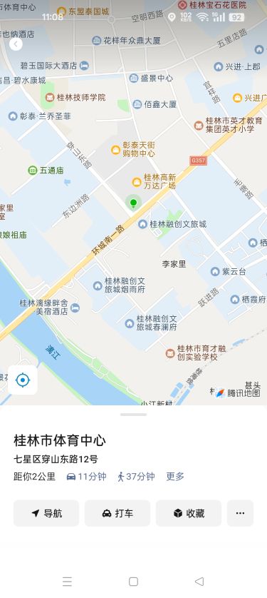
[] 打开桂林市体育中心;坐标可以事先查阅好
wx.openLocation({
    latitude: 25.26,
    longitude: 110.32,
    name: '桂林市体育中心',
    address: '七星区穿山东路12号'
})
wx.chooseLocation(Object object)
- 分类:位置接口
- 打开地图选择位置
chooseLoc() {
    wx.chooseLocation({
        success: res => console.log('chooseLocation ok', res),
        fail: err => console.log('chooseLocation fail', err)
    })
}
wx.choosePoi(Object object)
- 分类:位置接口
- 打开 POI 列表选择位置
choosePoi() {
    wx.choosePoi({
        success: res => console.log('choose poi ok', res),
        fail: err => console.log('choose poi fail', err)
    })
}
choosePoi:fail 开发者工具暂时不支持此 API 调试,请使用真机进行开发
wx.chooseAddress(Object object)
- 分类:开放接口
- 获取用户收货地址。调起用户编辑收货地址原生界面,并在编辑完成后返回用户选择的地址
chooseAddr() {
    wx.chooseAddress({
        success: res => console.log('chooseAddress ok', res),
        fail: err => console.log('chooseAddress fail', err)
    })
}
[] map 基本使用
- 配置 app.json - 只需配置一次,全局生效
- 根据需要的具体业务指定
"requiredPrivateInfos":[
    "getLocation",
    "chooseLocation",
    "choosePoi",
    "chooseAddress"
]
"permission": {
    "scope.userLocation": {
        "desc": "你的位置信息将用于小程序位置接口的效果展示"
    }
}
<map
    class="map"
    id="map"
    longitude="{{longitude}}"
    latitude="{{latitude}}"
    markers="{{markers}}
    show-location
    show-scale
    show-compass
    bindtap='getMapInfo'
    bindmarkertap="getMarker"
    bindlabeltap="getLabel"
    bindcallouttap="getCallout"
    bindregionchange="changeRegion"/>
<image
    class="img"
    src="../../utils/center.png"
    mode="aspectFill"
    bind:tap="moveToLocation" />
map{
    width: 100vw;
    height: 100vh;
}

.img {
    position: fixed;
    bottom: 20px;
    left: 20px;
    width: 30px;
    height: 30px;
}
let mapCtx;

Page({
  data: {
    longitude: "",
    latitude: ""
    markers: []
  },

  onLoad(options) {
    mapCtx = wx.createMapContext('myMap')
    wx.getLocation({
      type: 'gcj02',
      success: res => {
        this.setData({
          longitude: res.longitude,
          latitude: res.latitude
        })
      },
      fail: err => console.log('getLocation fail', err)
    })
  }
})
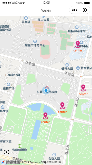
addCenterMarkers(lati, long) {
    let markers = this.data.markers
    let ind = markers.length
    let marker = {
        id: ind,
        latitude: lati,
        longitude: long,
        iconPath: '../../utils/marker.png',
        width: 32,
        height: 32,
        callout: {
            content: 'top',
            color: '#ff4400',
            textAlign: 'center',
            display: 'BYCLICK'
        },
        label: {
            content: 'center',
            color: '#ff4400',
            textAlign: 'cneter'
        }
    }
    markers.push(marker)
    this.setData({
        markers
    })
}
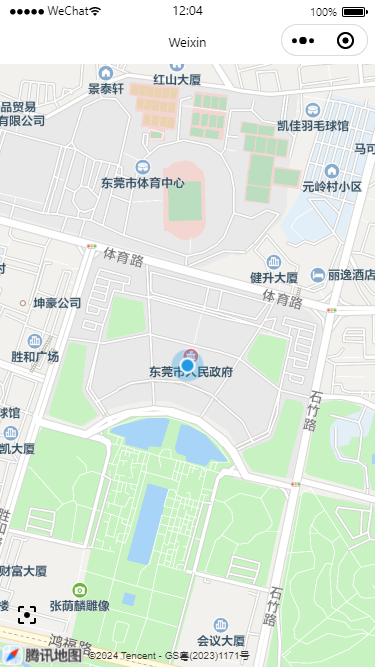
moveToLocation() {
    mapCtx.moveToLocation({
        longitude: this.data.longitude,
        latitude: this.data.latitude
    })
}
changeRegion(e) {
  console.log('moving', e);
}
getMapInfo(e) {
    console.log(e);
    wx.showToast({
        title: 'map tapped',
    })
    // 每次单击地图时,增加一个 markers
    this.addCenterMarkers(e.detail.latitude, e.detail.longitude)
},

getMarker(e) {
    console.log('marker tap', e);
    wx.showToast({
        title: 'marker tapped',
    })
},

getLabel(e) {
    console.log('label tap', e);
    wx.showToast({
        title: 'label tapped',
    })
},

getCallout(e) {
    console.log('callout tap', e);
    wx.showToast({
        title: 'callout tapped',
    })
}
开发工具的模拟器和预览、真机调试有差别